
Travel in Georgian times
Go back to The Georgians. See also Cheese and Pies and Canals.
But first - the Romans
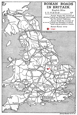
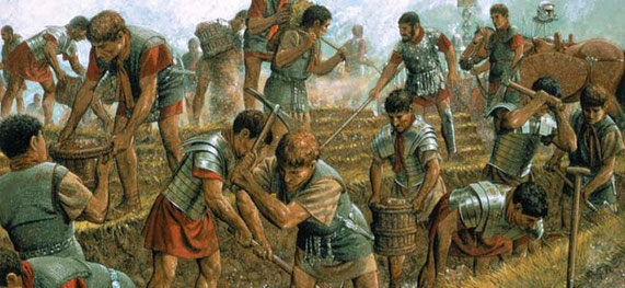
2000 years ago, when the Romans invaded, the first thing they did was to build forts to protect themselves. The second thing they did was to build roads so that the Roman army could march quickly across the country. Their roads were straight and well maintained.
The Roman roads were not the only roads in England. There were many many rough tracks from field to field and from village to village used by ordinary Ancient British farmers, but the Roman roads were the best.
Click here to go back to Roman Britain.
Travel
Then the Anglo-Saxons

The Anglo-Saxons settled in Britain after the Romans left and they continued to use the Roman roads. But they did not mend the roads or bridges. The roads soon became bumpy muddy tracks and the bridges fell down.
There were people who travelled long distances in Anglo-Saxon England - merchants buying and selling goods, armies sometimes.
But ordinary people used the rough tracks to go to work in the fields, to go to the next village or to go the market at Bingham, just like the Ancient Britons had.
Click here to go back to the Anglo-Saxons.
Travel
The Middle Ages
By the end of the Middle Ages, the state of the roads was a real problem.
The population had grown and merchants wanted to take goods to sell around the country. But in summer travel was difficult; in winter travel was often impossible.


The people of each parish were supposed to look after the roads. Poorer people had to mend the roads for no pay; rich people had to pay a tax. But local people did not want to spend their time mending long-distance roads that they did not use, roads for travellers who were just passing through their village.
Something had to be done . . .
The Georgians
Turnpike Roads
In 1663 a group of wealthy people proposed to Parliament to improve part of the Great North Road between Wadesmill in Hertfordshire and Stilton in Huntingdonshire. They would put a better surface on the road and mend the bridges. To pay for this, they would set up a toll bar at each end of the road where travellers had to pay to pass. The toll bar was called a turnpike and the road was called a turnpike road.
The idea caught on.
By 1750 most of the main roads from London were turnpiked.
Turnpike mania!
- Between 1751 and 1772 turnpikes covered more than 11,500 miles of road in England.
- By 1836 Parliament had passed 942 Acts for turnpikes in England and Wales.
- By 1836 turnpike roads covered 22,000 miles, one fifth of the entire road network.
Turnpike Roads in Nottinghamshire
-
The first turnpike in Nottinghamshire was a stretch of the Great North Road at Grantham in 1725.
(The Great North Road ran from London to York and Edinburgh often following the route of the old Roman road, Ermine Street.)
- Nottinghamshire's second turnpike was the road from Nottingham to Loughborough in 1737.
Other turnpike roads followed:
- Nottingham to Bingham and Grantham in 1759
- Nottingham to Melton Mowbray in 1753
- Bingham to Newark in 1773
- and more . . .


Click the map to see all the turnpike roads of Nottinghamshire. →
Click again to make it larger.
Map by Alan Rosevear on www turnpikes org uk.
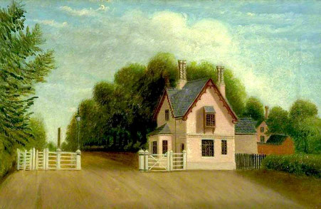
Toll houses
The turnpike trusts laid new road surfaces and mended the bridges on a stretch of road. Sometimes they built new roads.
The turnpikes went between large towns and passed through small villages on the way.
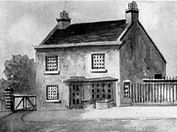
As you left a town or village, there was a gate across the road with a house for the toll collector. The house would have a bay window like the one in the picture. This was so the tollgate keeper could see traffic coming from either direction.
There was a board with a list of charges for horse riders, carriage and carts, herds of cows or sheep. If you walked, it was free!


↑ Above:
You had to pay to go over the Wilford toll bridge up until 1969. Here is the scale of charges on Wilford Bridge toll house in Nottingham - rather later than Georgian - it's still there.
← Left:
It cost one penny for four sheep when this photograph was taken in the 1950s.

Road signs giving directions and showing distances are very common nowadays.
Milestones/ Mileposts
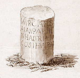
You might guess . . . The Romans did it first!
← A Roman milestone discovered in 1771 on the Fosse Way near Leicester. It was probably put here when they were repairing the road ready for a visit by the Emperor Hadrian in AD 120.
This is the first Roman inscription found in Britain. It is in abbreviated Latin: "IMP CAES DIV TRIAIN PARTH F DIV NEP TRIAIN HADRIAN AVS P P TB POT IV COS III A RATIS M II".
Translation: "Emperor Caesar Trajan Hadrian Augustus, son of the defied Trajan, conqueror of Parthia, grandson of the deified Nerva, father of his country, in the fourth year of tribunucian power, three times consul, from Ratae 2 miles".
Ratae was the Roman name for Leicester.
The Fosse Way was an important Roman road road running from Exeter in the south-west of England, through Nottinghamshire, to Lincoln in the north-east of England.
The Georgians
Milestones on the turnpikes
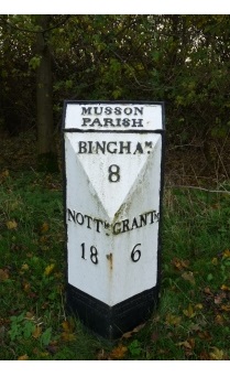
The Romans did it first - and it was 1600 years before milestones were set up by the turnpikes trusts in Britain in the 18th century.
← A milepost on Grantham Road between Bottesford and Muston. It was made in cast iron by Boothby & Company of Nottingham and put here by the Grantham & Nottingham (East Division) Turnpike Trust in the early 19th century.
(Muston is a little village near Bottesford, Nottinghamshire. Its name used to be 'Musson' and some local people do call it 'Musson' even though it is now spelled 'Muston.')
Stagecoaches

Even before the turnpikes were set up, there were stagecoaches carrying people and carts carrying goods across the country - though it was long and slow.
This is an advert from 1698:
The Nottingham Flying Coach
- in two days -
twice every week
Sets out from Nottingham every Tuesday and Thursday morning at 4 o’clock and will be at the Ram Inn West Smithfield, London the next day, and sets out from The Ram Inn, West Smithfield, every Tuesday and Thursday. Performed, if God permit, by Charles Hood, Richard Tuffin and Edward Wilkinson.

By 1836, travelling along the turnpikes, the journey from London to Nottingham was much quicker, taking 15 hours to go 124 miles. You left the Swan with Two Necks inn at 6.45 am. There were only 4 seats inside the coach and 8 outside - sitting on top or by the driver, which was cheaper.
Even along the turnpikes, it was a bumpy ride!
No turnpike road in Langar ???


The tiny villages of Langar and Barnstone were not on a road between larger towns. They were (and still are) villages in the middle of farming countryside. Our villages produced farm goods (crops and animals) which were sold at nearby markets such as Bingham, Nottingham and Melton Mowbray.

Because the markets were nearby, for the farmers of Langar and Barnstone, it was not too much of a problem that there was no turnpike here.
Not that the roads round here were good - they weren't!
This story was told by Samuel Butler of an incident in the 1830s:
"My uncle and aunt came to stay at the Rectory. My father, the Rector took them for a drive to Colston in his horse and carriage. The roads were in those days notoriously rough, indeed in winter they were almost impassable, but this was summer.
My uncle, who was nearly blind, said, ' I have heard about your roads and I am not surprised to be jolted.'
My aunt explained that my father was driving in the ruts.
My uncle laughed and said, "Ha ha! Let him drive in the ruts if he wants to!"
Edited
A Georgian success story!

For 100 years during the Georgian era, people travelled on the turnpike roads across England, Ireland, Scotland and Wales.
The impact on trade locally and nationally was enormous: business-people and sales-people could travel the country more quickly and reliably than ever before, and their goods could be shipped in greater quantities and faster than ever.
The End
The last road to be turnpiked was a stretch of just two miles near Hastings in Sussex in 1836. The turnpike roads continued to boom until the middle of the 19th century.

What killed the turnpikes?
The railways.
Turnpikes could not compete with the speed or capacity of railways for long-distance traffic. Many turnpike trusts got into debt and the condition of the roads grew worse.
The government abolished all the turnpikes in 1888 and gave the responsibility for looking after long-distance roads to the county councils, and the responsibility for local roads to parishes and townships.
Weblink

A video from the BBC:
Why did Britain need a better road network?
The link takes you out of this website.

Pies and cheese
What on earth have the turnpikes got to do with pies and cheese?